Subsidence in Tianjin caused by water extraction
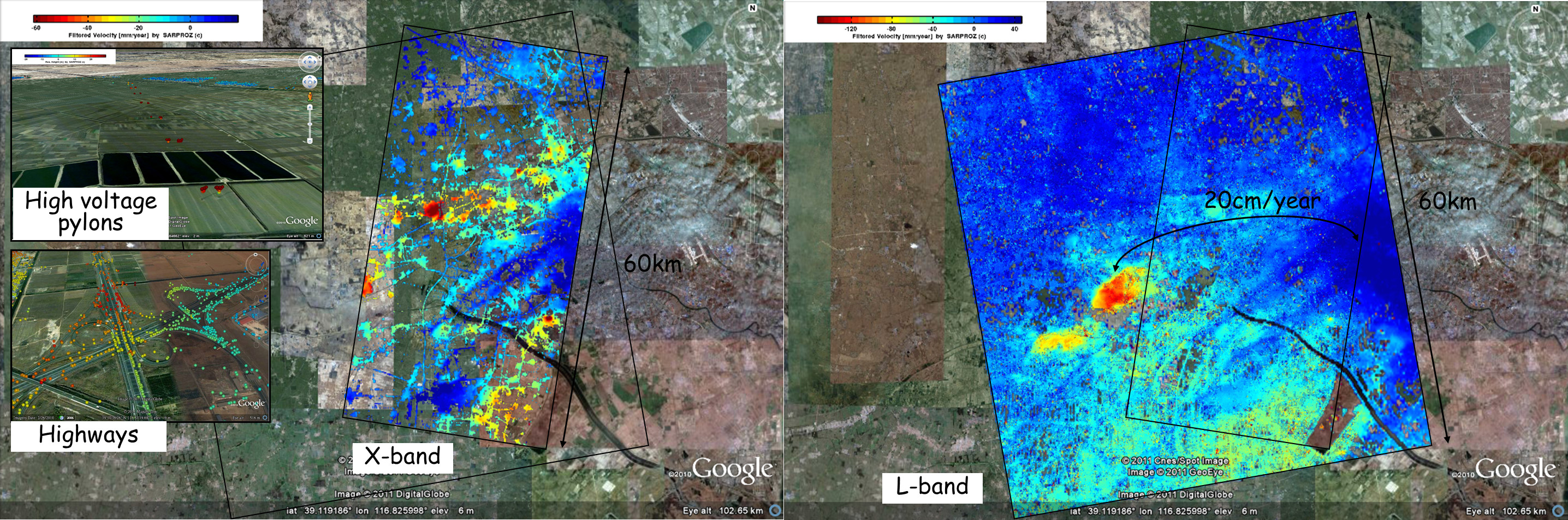
The image on the left shows the subsidence trend detected with a stack of TerraSAR-X data (Persistent Scatterers approach). In the image on the right the movement comes from an analysis based on ALOS images (decorrelating targets approach). The strong subsidence is caused by the extraction of underground water.
-
![[PDF]](https://www.sarproz.com/wp-content/plugins/papercite/img/pdf.png)
![[DOI]](https://www.sarproz.com/wp-content/plugins/papercite/img/external.png) Q. Luo, D. Perissin, H. LIN, Y. Zhang, and W. Wang, “Subsidence Monitoring of Tianjin Suburbs by TerraSAR-X Persistent Scatterer Interferometry,” IEEE JSTARS, vol. Vol. PP, 2013.
Q. Luo, D. Perissin, H. LIN, Y. Zhang, and W. Wang, “Subsidence Monitoring of Tianjin Suburbs by TerraSAR-X Persistent Scatterer Interferometry,” IEEE JSTARS, vol. Vol. PP, 2013.
[Bibtex]@Article{luo-smotsbtpsi2013, author = {Luo, Q. and Perissin, D. and LIN, H. and Zhang, Y. and Wang, W.}, title = {Subsidence Monitoring of Tianjin Suburbs by TerraSAR-X Persistent Scatterer Interferometry}, journal = {IEEE JSTARS}, year = {2013}, volume = {Vol. PP}, doi = {10.1109/jstars.2013.2271501}, owner = {periz}, timestamp = {2015.02.08}, } - Q. Luo, D. Perissin, Y. Zhang, and Y. Jia, “L- and X- Band Multi-Temporal InSAR Analysis of Tianjin,” Remote Sensing, p. 7933–7951, 2014.
[Bibtex]@Article{luo-laxbmiaot2014, author = {Luo, Q. and Perissin, D. and Zhang, Y. and Jia, Y.}, title = {L- and X- Band Multi-Temporal InSAR Analysis of Tianjin}, journal = {Remote Sensing}, year = {2014}, pages = {7933--7951}, doi = {10.3390/rs6097933}, owner = {periz}, timestamp = {2015.02.08}, }